
Imagine a situation when you are happy to drive within the speed limit, no not because there is a lot of traffic or cops, but when the limit itself is 80mph, why do you need to speed? That's the case with Utah highways; you hardly see any traffic on both the I-15 and I-70 stretches on the way to and from Utah’s majestic canyons. The state is so huge with a population of just over 2 million; and this shows on the long, straight stretches of interstates and other highways. It reminded me of what Brian used to tell about the American West and the distances.
It's been more than a month but the majestic images of the canyons, the meandering river in the deep gorge, and, yes, the intense heat vividly linger in the minds. First part of June is generally a good time to visit Utah canyons with temperatures in the range of 30-32C (86-90F); however when we visited the canyons, a heat dome engulfed the entire Southwest US and temperatures ranged from 38-42C (100-107F) for the first half of our trip. Luckily, Kshama had packed 3 umbrellas with us. We got compliments from a bunch of folks as we were creating our own shade in the scorching heat. This shade and the ample amount of water we drank helped us hike 5-7 miles and about 300-400 feet of elevation each day. So did the AC in our car.
After wasting almost an hour at the airport to get the rental car we had booked, we stocked up on water and coconut water from Salt Lake City Costco. Space, plenty of it, is the hallmark of Salt Lake City establishments, be it the airport or Costco or the wide lane roads in the city or the expansive single story houses. We then dined at one of the best restaurants in the city, an Indian restaurant, Bombay House, knowing that Indian food will be a luxury item for the next 6 days. We then headed to Cottonwood Canyon, famous for ski slopes. While we did see little snow on the top of the mountains, the amount of water flowing through the river in the canyon was enormous.

Cottonwood Canyon
It’s a small world. During our stay in Salt Lake City, we got to know that one of Kshama's schoolmates, Jatin, was visiting from Ohio and was staying close to our hotel, Hyatt Place. We met him over breakfast the next day.
After breakfast, we started our long drive to Arches National Park, picking up lunch from Chipotle, another hard to find restaurant elsewhere in Utah. The traffic really died down after we took the Spanish Fork and went onto I-70. After about a 4 hour drive, we reached Arches NP. They have instituted a new timed entry permit valid for 1 hour. If it wasn’t for this, we could’ve switched everything around and visited Arches when it was cooler. We had taken 2 passes for both the days we visited the park on Kshama's and my names.
We reached just in time to use either of the passes (3-4 or 4-5 pm). After purchasing America the Beautiful national park pass, we straight away went for sightseeing. After spending time at Park Avenue, La Sal Mountains, and the Courthouse Tower, we went on a small hike to see the Balanced Rock. The rock appears to be glued on! The truth is that Balanced Rock, like most of the other formations in this park, was formed by erosion and fault movement.

Park Avenue
We then headed to the Lower and Upper Viewpoints for the Delicate Arch, the landmark of the park and also the state (used by their DMV). As if climbing around 200' was not enough, we embarked on a 3-mile round trip hike, which climbs 550', over some steep, rocky terrain, to view the Delicate Arch up close. It was 7:15 in the evening, but the temperatures were still in the 30s (upper 80s F).

Delicate Arch @ Sunset
We reached the arch at around 8:20 just in time to get glimpses of the arch in the setting sun. Sunset is the best time to view the arch as lighting is perfect then. After spending half an hour and eating the home packed puri-bhaji dinner, we started our descent. We had a lot of company, so even after it was dark, it didn't feel too dangerous as long as you maneuver the rocky patch carefully and in some light. We reached the parking spot at 9:50 pm, in complete darkness. We then immediately headed to our Moab hotel, Scenic View Inn.
The breakfast at different hotels all these days was predictably the same, with juices, bread, hash browns, scrambled eggs, pastries and coffee, a typical continental breakfast.
After packing lunch from Subway (there are no restaurants in these parks), we headed to Arches for one more day, again reaching in time for the 11-12 timed entry. We went directly to the far end of the park to view Skyline Arch and then Sand Dunes Arch, the only shaded hike! That’s why it’s suggested to do this at midday.

Skyline Arch
We came out of the park and visited the Colorado River drive for an hour or so. It was 3 pm, and we hoped the river would be cooler. It seemed enormous, but the water levels were only a fraction of what they once were. Then, we went to Moab to pick up dinner from Quesadilla Mobilla, headed back to the park to catch the 4-5pm timed entry, had our packed dinner at the visitor center, and visited the remaining spots.
I met one of my colleagues, Akshay, on the North and South Windows hike. Yep, it’s a small world, I told you! He was visiting with his parents. After hiking to Turret Arch and then to Double Arch, we went back to the far end of the park to hike in Devils Garden. It was getting dark so we decided to limit our hike to Landscape Arch only and not further, to cover a 7-mile hike! This time, we did not have as much company except for a few people and a deer, no devils!

North and South Windows from Turret Arch

Double Arch

Landscape Arch
After saying goodbye to the park we went back to the hotel, which is managed by a young Indian and his family!
After picking up Subway sandwiches, we headed to Canyonlands National Park, where another hot and windy day lay in store for us. Canyons in this park are carved by the Colorado and Green Rivers. There are 3 distinct levels in the park, most of the visitors are on the Mesa flat (table top), then there is another level about 1400' below, whose edges are white, hence called the White Rim. Another 2000' below are the rivers who are still cutting the canyon.
We started our day with Mesa Arch, which is supposed to be even beautiful at sunrise as the sun rays illuminate the bottom of the arch. A short hike takes you to the arch. You will find a lot of company there. It's a challenge to take pictures of the arch without a lot of folks in the frame.

Mesa Arch and the canyon below
Then onto Grand Viewpoint, a befitting name for the point. We didn't take the hike there; instead we hiked to the White Rim Overlook. You can take a 4x4 vehicle and descend 1400' below to drive on the White Rim, a total of 100 miles. From the Shafer Canyon overlook, we saw a vehicle riding back to the Mesa flat using this particular road. In the olden days, this was a trail for horses and people.
The White Rim Overlook was a longer hike, all in the scorching sun with no shade and lots of wind. It was a challenge to keep the umbrellas intact! After taking in the beauties from the Green River overlook and from across the visitor center, we headed out of the park and then visited Dead Horse Point State Park, from where you see the Colorado River up close, well still 3000' below. Dead Horse is surely underrated!

View from White Rim Overlook (with river in the middle)

It would take us 2 and half hours to reach our destination, Torrey, a small village near Capitol Reef national park and by the time we would reach, most of the (handful of) restaurants there would close, so we decided to take a detour and eat at Pizza Hut in Moab. The temperature has cooled down to a balmy 34C (93F) by now, from a peak of 42C (107F) while we were hiking on the White Rim Overlook trail! As I mentioned, a heat dome had engulfed the entire Southwest (proof that climate change is real!). The temperature in Moab that day shattered all records!
We reached Torrey at 10:30pm and by that time the hotel's front desk was closed. Luckily, I had called from Moab to get instructions to get the room key after hours, so we were able to get into our room.
The drive to Torrey was lonely and dark. We couldn’t help but wonder how the pioneers of the 1800s crossed this desert. At least they would’ve had company, but Utah was the most dangerous segment of the Oregon Trail. That is, of course, not considering the fact that they could’ve caught some nasty diseases anywhere. Speaking of disease, COVID wasn’t much of a danger for most of the trip. By nature of the state and the trip, we were social distancing and didn’t need to wear masks. We passed through the Capitol Reef Park and could sense that that portion of the drive must be scenic, so decided to cover this part the next day, even though it meant going back 10-15 miles.
Capitol Reef is a relatively small park. We started with the Hickman Natural Bridge trail but abandoned it halfway as it was in the scorching sun without any shade. We then took the scenic route to the other end of the park. The road turns into a 2 mile gravel road to reach the Capitol Gorge (it took us 20+ minutes to cover these 2 miles). Theoretically, you need a 4x4 to drive on this road, but what happens in theory isn’t always reality. We took a hike in the gorge to view the pioneer museum where Mormon pioneers etched their names and dates on the canyon walls in the 19th century. This narrow gorge made the wind even more fierce!

The Pioneer Museum
We then stopped in the Fruita district, sat on picnic tables under trees and ate trail mix. This was the most relaxing (and shaded) half hour of the entire trip!

Frutia District
We then saw the Petroglyph, another graffiti on canyon walls, only that this was etched by Native Americans a few centuries ago. They seemed to predict the future. We then went back on the scenic road we missed because of the dark the previous day. On this road was Chimney Rock, a landmark on the Oregon Trail.
After visiting Chimney Rock, Panorama, and Sunset Points, we looked for a good restaurant in Torrey for dinner. Luckily or otherwise, there were only a few restaurants in the village. After having a delicious dinner at a Mexican restaurant, Chak Balam, we started on another 2 and half hour drive, to Bryce.
Ruby Inn in Bryce Canyon is the closest you can stay near Bryce Canyon unless you are staying in Bryce Canyon Lodge itself. Our room was in the Lakeview Lodge. Ruby Inn is a sprawling complex of multiple lodges.
The antepenultimate day of our trip was a long, action packed day from before sunrise to well past sunset, with close to 10miles of hiking and an elevation gain of more than 1000 feet. Most of it came from the Queen’s Garden and Navajo mountain combination trail, which itself has 650' of elevation gain and is over 3 miles long. The trail starts from Sunrise Point, and you come back up to Sunset Point. Then you also have to cover the Rim Trail from Sunset Point back to Sunrise Point to get back to your car. You start the trail from a point above most of the hoodoos, descend quite a distance to the bottom of the hoodoos, go through the forest at the base, and come back up. The last quarter mile to reach the sunset point is really steep.

View from Queen’s Garden Trail
At dawn, we headed into the park to watch the sunrise from Sunset Point. We believe this is a better place to watch the sunrise, better than Sunrise Point itself. We waited half an hour for the sun to rise, taking in the beauty and changing colors of the hoodoos. We were the first ones to reach the point, but just before sunrise, we had quite a bit of company. A few people had descended some 50 feet down the Navajo Trail. We thought there was no way we’d do that. It turned out we didn’t do just that; we did so much more!
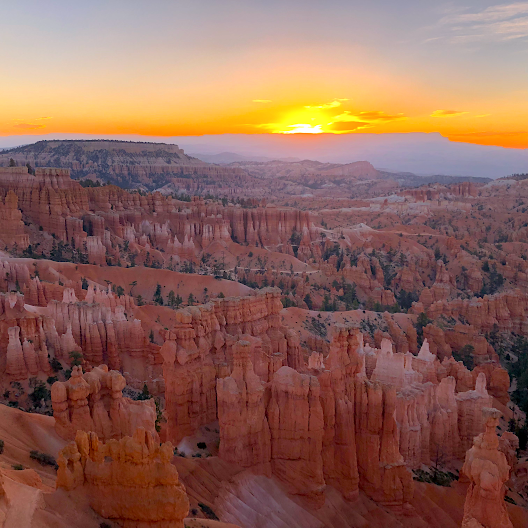
Bryce Canyon @ Sunrise
After breakfast and the midday combination trail hike, we went to Lower and Upper Inspiration Points. You get to see hoodoos from different angles from various viewpoints and from wherever you see them, the view is pretty. After visiting Bryce Point, we went on a drive to the end of the park, spent time at multiple viewpoints to take in the different scenery they had to offer and reached the Rainbow/Yovimpa point parking lot. These 2 points offer their unique views and there is an alpine trail (we were at 10000' above sea level) between these 2 points. We quickly finished the mile long trail before heading back out of the park.

Bryce Canyon Amphitheater
After grabbing sandwiches from Subway (yes, Subway was the most common and readily available eating place around the canyons), we went back to the park and watched sunset from the sunset point. The night sky in Bryce Canyon is really pretty, but this was a full moon night and the sky turned partly cloudy, so although we waited for dark after sunset at the inspiration point, we didn't have enough luck to spot stars and galaxies.
Bryce Canyon NP, with its lowest (park level) elevation at 8000' offered us pleasant and sunny weather with temperature reaching only 28C (lower 80s F) and also trees. This was a huge respite from earlier days of scorching heat.
The next day started with Mossy Cave and Waterfall trail. This trail, unlike other trails in Bryce, starts at the bottom of the hoodoos. It's a nice trail with good views, although Mossy Cave itself is an overrated attraction!

Mossy Cave Waterfall
We then spent some time at Kodachrome Basin State Park and then headed back to Provo. Adaptive cruise control on the rental car was the savior on the long 4 hour drive mostly on I-15, with a speed limit of 80mph. We reached Provo in the evening just in time for dinner at Bombay House, the best overall restaurant in Provo. But the wait was 1 hour so we went to a nearby Thai restaurant which is also highly rated.

Red Canyon
After dinner, it was still daylight, so we visited Provo Canyon and watched the Bridal Veil Falls before going to our hotel, Holiday Inn Express.

Bridal Veil Falls
We had shortlisted a few attractions in Salt Lake City, so after visiting the Utah University campus, we went directly to the Governor's Mansion (the first one we’ve actually visited) and then to the State Capitol. Most of the State Capitol buildings I had seen earlier have a huge but single building which houses both the state senate and the house. But Utah has different buildings for the House and Senate apart from the main building with rotunda, and all of them are super size buildings. The 360 degree view from Capitol Hill is awesome.

Utah State Capitol
We then drove around the Temple Square, which has a lot of construction going on, so we didn't stop by. After filling in gas from Costco, we picked up pizza from The Pie Pizzeria and headed back to the airport.
ReplyDeleteGreat experience. Very descriptive. Nice. Your article can be referred by the travellers that are interested to visit the places. Inspiration for others to visit. Thanks for attaching Brochure Maps
🙏
Delete